We at the Bureau of Business and Economic Research (BBER) are always on the lookout for new and useful datasets, especially those that showcase data at the county and local level. Recently, while on the U.S. Census Bureau’s website, I (BBER director Monica Haynes) came across the Census Bureau’s Community Resilience Estimates (CRE for Equity) dataset, which measures a community’s capacity to absorb the external stresses of a disaster. This information caught my eye, especially given the BBER’s recent research on Duluth’s reputation in the media as a climate destination for those seeking relief from the adverse effects of climate change.
The data included in this dataset and the corresponding map could be particularly useful to policymakers, nonprofits, and government agencies looking to better understand which factors make their community resilient to natural disasters and which factors put their communities at risk. It could also be useful in identifying how community resiliency in a given location compares to other areas within the U.S.
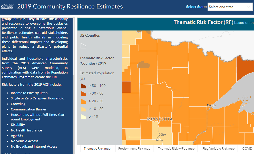
Dataset name: Community Resilience Estimates Equity Supplement (or CRE for Equity)
What does it measure?
According to the U.S. Census Bureau, community resilience is the capacity of individuals and households within a community to absorb the external stresses of a disaster. The CRE for Equity dataset provides information on community resilience for the nation, states, counties, and census tracts from three different data sources. The database allows users access to a variety of topics related to social vulnerability and equity, including poverty, disability, health insurance, broadband access, and communication barriers.
Some interesting findings:
- Despite Duluth being labeled a climate refuge by many in the news media, more than 20% of St. Louis County residents have three or more risk factors that make them more vulnerable to natural disasters (risk factors are shown below). This is slightly higher than the state average (17.4%). In Duluth’s Central Hillside neighborhood (census tract 19), more than 50% of residents have three or more risk factors.
- Within the Arrowhead Region, Cook County residents are some of the most vulnerable in the state, with 31.2% having three or more risk factors. Taking the entire state into consideration, only Mahnomen County has a higher share (33.9%) of vulnerable residents than Cook County.
- The most resilient counties in the state, from a community resiliency standpoint, are primarily located in and around the Twin Cities metro area. These include Sherburne (10.9% of the population have three or more risk factors), Scott (11.0%), Wright (11.9%), Dodge (12.2%), and Carver Counties (12.3%).

Specific measures included in the dataset:
Risk Factors
- Income-to-Poverty Ratio (IPR) < 130% (household)
- Single or zero caregiver household—only one or no individuals living in the household who are 18-64 (household)
- Unit-level crowding with >= 0.75 persons per room (household)
- Communication barrier defined as:
- No one in the household has received a high school diploma
- No one in the household speaks English very well
- Aged 65 years or older
- No one in the household is employed full-time, year-round. This flag is not applied if all residents of the household are aged 65 years or older (household)
- Disability, at least one serious constraint to significant life activity
- No health insurance coverage
- No vehicle access (household)
- Households without broadband internet access
Image source: U.S. Census Bureau